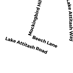
35 LAKE ATTITASH RD
Owner Information
MERCER STEVEN A
48 LAKE ATTITASH RD
AMESBURY, MA None


Property Details
35 LAKE ATTITASH RD is classified as a Undevelopable Residential Land (Vacant land).
35 LAKE ATTITASH RD is valued at 11600. The land is valued at 11600 and the structures are valued at 0.
This property is in Zone OSC. Confirm with local Zoning Board authorities to ensure there are no overlays or other easements on this property.
The most recent deed for 35 LAKE ATTITASH RD is recorded at the local registrar in Book 12549, Page 536. 35 LAKE ATTITASH RD was last sold on 1994-04-29 for 130000.
Assessment data from fiscal year 2022.
Flood Data
According to the FEMA National Flood Hazard Layer, this property does not appear to be in a flood zone. It may also be in an area not yet reviewed. Nonetheless, confirm this information prior to taking any action.
To view the flood hazards around this property, create a FEMA "Firmette" Map of the area around 35 LAKE ATTITASH RD.
Broadband Internet Providers
| Provider | Type | Bandwidth (mbps) | |
|---|---|---|---|
| HughesNet | Satellite | 25 | 3 |
| Comcast | Cable | 1000 | 35 |
| Verizon New England Inc. | DSL | 5 | 0 |
| Viasat Inc | Satellite | 100 | 3 |
| VSAT Systems, LLC. | Satellite | 2 | 1 |
| GCI Communication Corp. | Satellite | 0 | 0 |
Broadband service provider data from December 2020.
Adjacent Properties
- 47.5 KIMBALL RD
Potentially Developable Residential Land owned by BC REALTY TRUST - 43 LAKE ATTITASH RD
Single Family Residential owned by JENKINS WENDELL N II - 45 LAKE ATTITASH RD
Single Family Residential owned by MATOS RACHAEL - 47 LAKE ATTITASH RD
Accessory Land with Improvement owned by SENECHAL-BROWN ELAINE - 49 LAKE ATTITASH RD
Accessory Land with Improvement owned by JUNE C. PASTMAN REVOCABLE TRUST - 51 LAKE ATTITASH RD
Single Family Residential owned by SVETAKA PATRICE A - 57 LAKE ATTITASH RD
Single Family Residential owned by JUTRAS J NORMAND